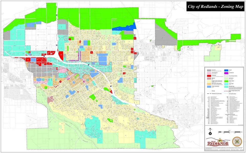
Download a High Resolution PDF Map of Redlands Zoning
Zoning Districts
Title 18 of the Redlands Municipal Code is the City’s Zoning
Ordinance. and establishes the allowable land uses and
development standards for each zoning district. The chapters
within Title 18 (links provided below) provide the lists of
permitted and conditionally permitted uses. Each chapter below
also provides the relevant development standards, such as:
minimum lot size and dimensions, maximum lot coverage,
required yard areas, and maximum height. The City of Redlands
zoning districts consist of the following:
-
A-1, Agricultural (5 acre minimum lots)
-
A-1-20, Agricultural (20 acre minimum lots)
-
A-2, Estate Agricultural (1.5 acre minimum lots)
-
R-R, Residential Rural (1 acre minimum lots)
-
R-R-A, Residential Rural Animals (1 acre minimum
lots)
-
R-A, Residential Estate (20,000 sq. ft. minimum lots)
-
R-A-A, Residential Estate Animals (20,000 sq. ft.
minimum lots)
-
R-E, Residential Estate (14,000 sq. ft. minimum lots)
-
R-S, Suburban Residential (10,000 sq. ft.
minimum lots)
-
R-1, Single Family Residential (7,200 sq. ft.
minimum lots)
-
R-1-D, Single Family Residential (8,100 sq. ft.
minimum lots)
-
R-2, Multiple Family Residential (8,000 sq. ft.
minimum lots)
-
R-2-2000, Multiple Family Residential (12,000 sq. ft.
minimum lots)
-
R-3, Multiple Family Residential (10,000 sq. ft.
minimum lots)
-
A-P, Administrative & Professional Office
-
A-P-C, Administrative Professional Commercial
-
M-F, Medical Facility
-
E, Educational
-
C-1, Neighborhood Stores
-
C-2, Neighborhood Convenience Center
-
C-3, General Commercial
-
C-4, Highway Commercial
-
C-M, Commercial Industrial
-
M-P, Planned Industrial
-
M-1, Light Industrial
-
I-P, Industrial
-
M-2, General industrial
-
P, Off Street Parking
-
O, Open Land District
-
T, Transitional District
-
A-D, Airport District
-
Airport Flight Zones
-
HD, Hillside Development
-
C-D, Civic Design District
-
FP, Flood Plain District
To view or print the entire Zoning Code (Title 18 of the
Municipal Code), click here:
RMC Title 18
Transit Villages Specific Plan
Click here for link to the
Transit Villages Specific Plan
Other Specific Plans
Many properties are within a Specific Plan (and do not have
a Title 18 zoning designation). These areas are identified
on the Zoning Map as “SP__”.
To view relevant documents, go to our Specific Plans &
Community Plans webpage (click here).
If a specific plan document you are interested in is not listed,
please contact Planning staff for assistance.
Permitted Uses & Conditional Uses
“Permitted” Uses
A “permitted use” means a land use, business, or activity that
can be allowed in a zoning district or specific plan
district. Groupings of permitted uses means that they are
compatible land uses and do not cause major detrimental
costs or externalities on other uses permitted within the same
zone.
Where a property has previously been legally improved or
developed for non-residential use(s), and a new Permitted Use
wishes to occupy or utilize the subject property as is, then the
applicant may need only a Business License and Zone Clearance
approvals. For example, a new clothing store that wishes to move
into a retail suite within an existing shopping center would
typically only need to apply for a Business License (including
the related Zone Clearance Form). Another example is an office
use that wishes to move into an office building, that business
would typically only need to apply for a Business License
(including the related Zone Clearance Form). Additional
information about the City’s business license application and
review process is available here – www.cityofredlands.org/post/business-license-zone-clearance-application.
Changes of use for an existing developed non-residential property
(such as a new restaurant wishing to move into a space that was
previously used as an office use or a retail store) may require
additional ministerial permits even if a discretionary permit is
not necessary. Often such ministerial permits will include: a
building permit and inspections (e.g., interior tenant
improvements); engineering permit (e.g., exterior improvements,
grease interceptor, or ADA-accessibility improvements); Fire
Dept. permit (e.g., new fire sprinklers or a kitchen hood
system); and/or a Certificate of Occupancy (for the new use and
occupancy rating of the space).
For projects involving site improvements, development, new
buildings, construction of an addition to an existing building,
or any conversion of unimproved land to an improved or useful
condition, then the Redlands Municipal Code (see
RMC Chapter 18.12) requires a Commission Review & Approval
(CRA) permit to entitle such a project within the City’s Title 18
zones. For properties located within other designated Specific
Plan areas (not Title 18 zoning), then other entitlement
processes may be specified according to a particular Specific
Plan (e.g., such as a “Planned Development” or a “Concept Plan”
approval required within the East Valley Corridor Specific Plan).
Obtaining a Commission Review & Approval involves a public review
process, including a decision from the Planning Commission.
Obtaining a Planned Development or a Concept Plan approval
involves a public review process, including a decision from the
City Council. After the land use entitlements have been obtained,
the developer can then proceed to obtain any necessary
construction permits that may be needed from the City (e.g.,
building permits, grading or engineering permits, landscape
permit, Fire Dept. permits, etc.) and a business license for the
authorized activity. A “permitted use” does not mean that a new
land use, business, or activity can be established on a piece of
vacant or unimproved land without first obtaining the necessary
permits and approvals from the City.
In Redlands, if a Socio-Economic Cost/Benefit Study is required
for a project, then the Socio-Economic Cost/Benefit Study
requires a public hearing with the Planning Commission (see
RMC Chapter 16.02). Such a public hearing is concurrent with
the review of a Commission Review & Approval permit or other
entitlement applications.
The lists of Permitted Uses are provided in the relevant sections
of the Zoning Regulations (RMC Title 18) as well as Specific
Plans of the City. Like zoning codes in many other cities,
it includes a provision for “similar uses” since it
is not practical to have an extremely long ordinance
listing every conceivable permitted use. If your specific
proposal or land use is not clearly identified in the zoning or
specific plan, then you are encouraged to contact Planning staff
for a determination of similarity to other listed uses. In most
cases, an administrative determination can be quickly made at the
staff level. Occasionally, if staff cannot identify an
appropriate land use category already listed in the zoning
district or specific plan, then it may be necessary to amend a
code section (note that only the Planning Commission, City
Council, or Planning department may initiate zoning code text
amendments).
For further information about the development/entitlement review
process in Redlands, please visit our Development &
Entitlement Process page here.
“Conditional” Uses
A Conditional Use Permit (CUP) allows for land uses that are not
typically permitted within a specific zoning district but could
be suitable under certain conditions. The proposed land use is
not automatically permitted by-right (i.e., without discretionary
review and approval), but may be allowable subject to
discretionary approval by the City. Conditional uses means
that they may be compatible (with Conditions of
Approval) and must receive a heightened level of review to
ensure they do not cause major detrimental costs,
externalities, or nuisances on other uses permitted within the
same zone or abutting zones.
The proposed land use is subject to the City’s discretion and
land use authority (most often the Planning Commission that is
appointed by the City Council to make land use decisions on
behalf of the City Council). Obtaining a Conditional Use Permit
involves a public review process, including a public hearing with
the Planning Commission. The Development Services Department will
mail a public notice to neighboring property owners within 300
feet of the subject property, a legal notice will be published in
a local newspaper of general circulation, and the public hearing
allows for opportunities for input from neighboring property
owners and the community.
A Conditional Use Permit is for a specific use and runs with the
land. There are four Findings that are required in order to
approve a Conditional Use Permit (see
RMC Chapter 18.192). A CUP does not entitle a property owner
for site improvement activities or site construction. To perform
site improvements (e.g., grading, paving, new landscape planters,
frontage improvements, and so on) or other substantial site
construction, the Redlands Municipal Code requires a Commission
Review & Approval (CRA) permit. There are three Findings that are
required in order to approve a CRA permit (see
RMC Chapter 18.12) plus architectural review criteria and
findings for any new structures. For properties located within
other designated Specific Plan areas (not Title 18 zoning), then
other entitlement processes may be specified according to a
particular Specific Plan (e.g., such as the East Valley Corridor
Specific Plan, or the Transit Villages Specific Plan, both of
which encompass large areas of the City of Redlands).
The lists of Conditional Uses are provided in the relevant
sections of the Zoning Regulations (RMC Title 18) as well as
Specific Plans of the City. Like zoning codes in many other
cities, it includes a provision for “similar uses” since it
is not practical to have an extremely long ordinance
listing every conceivable conditional use. If your specific
proposal or land use is not clearly identified in the zoning or
specific plan, then you are encouraged to contact Planning staff
for a determination of similarity to other listed uses. In most
cases, an administrative determination can be quickly made at the
staff level. Occasionally, if staff cannot identify an
appropriate land use category already listed in the zoning
district or specific plan, then it may be necessary to amend a
code section (note that only the Planning Commission, City
Council, or Planning department may initiate zoning code text
amendments).
For further information about the development/entitlement review
process in Redlands, please visit our Development &
Entitlement Process page here.
Zone Change
The City or an individual may wish to change a zone on a parcel
of land. Any proposed Zone Change must be consistent
with the City’s General Plan, in accordance with State
law. In order to file a request for a Zone Change,
applicants must complete the Legislative Application Form, submit
all required materials, and pay the applicable fee(s).
Review of the proposal will include a review and
recommendation by the Planning Commission, and the City
Council who will ultimately make the decision. In
addition, another requirement of this application may be a
Socio-Economic Cost/Benefit Analysis (prepared by staff) to
evaluate the economic effects of the proposal.
For further information, please refer to
the Development Process webpage
(click here). If a Zone Change is contemplated, it is
recommended that a potential applicant meet with Planning
Division staff early (prior to filing a formal application)
to discuss the idea or proposal. Go to the Contact
Us page for further information.
Other Helpful Links
Development in the vicinity of the Redlands Municipal Airport
(REI) may also be affected by the policies in the
Redlands Airport Land Use Compatibility Plan (ALUCP).
Further information (including land uses, maximum occupancy
or densities, noise contours, avigation easement or notice
requirements, etc.) is provided on the Specific Plans &
Community Plans webpage (click here).